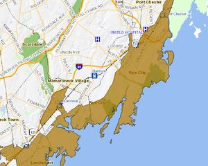
Map Shows Rye Hurricane Evacuation Zone
If you are uncertain, Westchester County has an interacive map that shows hurricane evacuation zones. The map shows many areas including all areas East of Boston Post Road as designated Hurricane Evacuation Zones.
Earlier in the day, Rye City encouraged all residents in flood prone area to evacuate by 7pm tonight (Saturday, August 27, 2011).
(PHOTO, BELOW: Yellow area shows hurricane evacuation zone.)


